City report · British Columbia, Canada
Vancouver Air quality today
Air quality in Vancouver currently reads AQI 26 (Good): Air quality is satisfactory for everyone.
Air quality right now
AQI 26
Good
- PM2.5, fine particles (µg/m³)
- 2.5
- tree cover
- 23.8%
- trees in this area
- 49.0K
- more trees needed
- 12.8K
Measured across a 2 km radius around Downtown Vancouver, Vancouver, BC, Canada (12.57 km²), from a satellite image of Sep 6, 2026. Lower AQI is better: 0–50 is Good, above 300 is Hazardous.
Vancouver · AQI 26 (Good)
Vancouver's tree count comes to 49,049 trees across 8.25 km² of land, 6 points below the 30% tree-cover level considered healthy for this area, so roughly 12,777 more trees would close the gap.
Air quality detail
Air quality in Vancouver today: AQI 26, Good
Main pollutant: Ozone · Observed Nov 11, 08:00 local time via OpenAQ ground stations, US EPA index. Values in µg/m³.
Ground station · Downtown Vancouver, 700 m away · median of 5 stations
Health signal
Air quality is satisfactory for everyone.
PM2.5
2.5
PM10
7.0
NO₂
23.4
O₃
55.0
SO₂
0.5
CO
229.1
Data: OpenAQ · AirGradient, AirNow, Emanuel
- Outdoor exercise
- A good day to be active outside
- Windows
- Open them to air the house
- Mask
- Not needed
- Air purifier
- Not needed
Over the last 7 days, the CAMS air-quality model put Vancouver's daily AQI at 47 on average, from 40 on Nov 6 to an hourly peak of 73 on Nov 9.
This is the US EPA AQI. How it differs from Canada's AQHI
Where Vancouver stands: the most polluted cities in the world right now · the cleanest
City air guide
Why does Vancouver get smoky air in summer?
Right now
- Today's AQI in Vancouver is 26, good, mostly from Ozone.
- Over the past 7 days, the daily average was 47.
Wildfire smoke can drift into Vancouver from fires in British Columbia and the western US [1][2]. Metro Vancouver says smoke affected the region's air in seven of the nine years up to 2023, and the highest monthly fine particle levels since 2013 were in 2017, 2018 and 2020 [1]. Hot, sunny weather also forms ground-level ozone, or smog, with the highest levels in eastern Metro Vancouver and the Fraser Valley [1].
What pollutants cause poor air in Vancouver?
Metro Vancouver, the regional district, runs the air monitoring network from Horseshoe Bay to Hope [1]. It says two pollutants are most likely to trigger a regional air quality advisory [1]. One is ground-level ozone, or smog, made by a chemical reaction on hot and sunny days [1]. The other is fine particulate matter, called PM2.5, tiny particles from wildfire smoke, home wood smoke, vehicle exhaust and industrial processes [1].
PM2.5 particles are small enough to be breathed deep into the lungs, affecting the lungs and the heart and blood vessels [2]. Ozone can irritate the eyes, nose and throat and reduce lung function [2]. The BC Centre for Disease Control says PM2.5 is the part of wildfire smoke that poses the greatest risk to health [4].
Canada's Air Quality Health Index, or AQHI, shows how air quality can affect your health [1]. It runs from 1, low health risk, to 10 plus, very high risk, and is updated every hour [1]. In 2023, 97 to 99 percent of hours were rated low risk in each part of the region [1].
How does wildfire smoke reach Vancouver?
Wildfires can make large amounts of smoke that travels great distances [2]. In 2017, winds carried smoke from fires in the BC Interior to the coast, and a haze fell over the Lower Mainland [3]. Environment Canada issued a number of special air quality and weather advisories for Metro Vancouver and the Fraser Valley that summer [3].
In 2018, BC had one of its worst wildfire seasons, with the largest area burned [2]. Plumes from fires in Washington state added to the smoke, and the Lower Mainland was under health advisories for 22 days in a row [3].
In 2023, Canada had its worst wildfire season on record, with over 18 million hectares burned [1]. Metro Vancouver felt the biggest smoke impacts in August 2023, when smoke from fires across BC and Washington led to two multi-day advisories [1].
What happened in September 2020?
Fire activity in BC was well below average in 2020, but smoke came from wildfires in Washington, Oregon and California [2]. On September 8, 2020, Metro Vancouver issued an advisory for fine particles as the smoke moved in [2].
From September 11, every monitoring station in the region was above the 24-hour PM2.5 objective for nine straight days [2]. That objective is 25 micrograms per cubic metre [1]. The highest daily level was 200 micrograms in Hope on September 15, 2020, about 8 times the objective [2].
The 11-day advisory ended on September 19, 2020, when cleaner marine air flowed into the region [2]. Meteorologists noted that the smoke reached BC later than usual, and that it did not come from BC's own fires [3].
Why does ozone build up in the Fraser Valley?
Ground-level ozone forms when nitrogen oxides and volatile organic compounds react in the air during hot, sunny weather [1]. Most nitrogen oxides come from transport, while volatile organic compounds come from trees, cars, light trucks and solvents [2]. The highest ozone levels are measured in eastern Metro Vancouver and in the Fraser Valley [1].
On May 15, 2023, Metro Vancouver issued its earliest ozone advisory since its advisory program began in 1993 [1]. May 2023 was unusually warm, and hot, sunny weather led to ozone advisories in May, June and July that year [1]. The 2023 summary says average ozone levels have risen slightly, partly because more ozone formed outside Canada comes into the region [1].
Is Vancouver's air getting better or worse?
Metro Vancouver's 2023 summary says most pollutant levels improved over the decade, even as the population grew [1]. Levels of nitrogen dioxide, sulphur dioxide and carbon monoxide generally fell, as engine and fuel standards for vehicles, ships and machinery improved [1].
In 2023, PM2.5 went above the 24-hour objective at every station, with wildfire smoke behind the high readings in June and August [1]. No station went above the annual objective [1]. Climate projections suggest hotter, drier summers, and a warming climate will likely bring wildfire smoke more often and for longer [1]. Metro Vancouver is updating its regional ozone strategy to account for hotter weather and wildfires [1].
How to protect yourself in Vancouver
The BC Centre for Disease Control says everyone can be affected by wildfire smoke and should act to reduce their exposure [4]. People at higher risk include those with asthma, COPD, heart disease or diabetes, pregnant people, infants and small children, and older people [4]. Check the AQHI to see local air quality [4].
To cut exposure, filter the air in one area of your home with a portable HEPA air cleaner or a do-it-yourself air cleaner [4]. Public spaces such as community centres, libraries and malls tend to have cleaner, cooler indoor air [4]. Limit outdoor exercise on smoky days, because the harder you breathe, the more smoke you inhale [4].
If you need to be outdoors, consider a well-fitted N95, KN95 or KF94 respirator [4]. On hot days, keep your cleaner air space cool, because overheating can cause serious health problems [4]. People with a chronic condition should make a plan for smoky days with their health care provider [4].
Sources
- [1] Metro Vancouver, 2023 Annual Air Quality Summary
- [2] Metro Vancouver, 2020 Lower Fraser Valley Air Quality Monitoring Report (December 2023)
- [3] CBC News, Smoked in: A look back at B.C.'s haziest wildfire seasons over the past 20 years (September 2020)
- [4] BC Centre for Disease Control, Wildfire Smoke
Last reviewed . The figures in the box at the top update with every new reading; the guide itself is checked against its sources at least once a year, before the city's bad-air season.
Tree cover detail
Tree cover in Vancouver: Below target
23.8% tree cover against a 30% healthy-neighborhood target, across 8.25 km² of land.
Trees in this area
49,049
Target trees
61,826
More trees needed
12,777
CO₂ if planted / yr
281.1 t
Deforestation · 2001–2025
How much forest has Vancouver lost?
Since 2001, the area within 10 km of Vancouver has lost about 272 hectares of forest (about 380 football pitches): 3.7% of the forest it had in 2000. Most of it (91%) was deforestation, forest cleared for good, mainly for towns and roads.
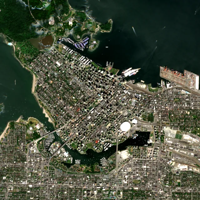
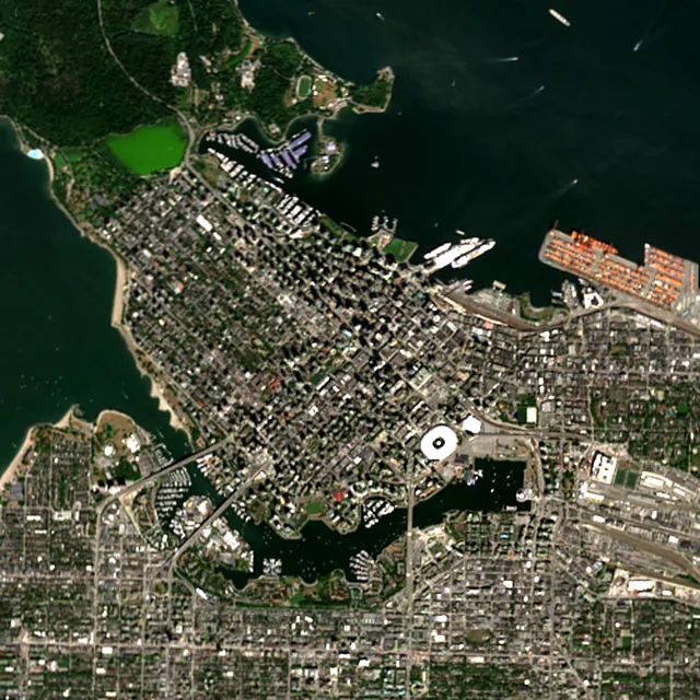

2017: satellite photo from July 2017 of a 5 × 5 km area in the city center.
- Forest lost since 2001
- 272 haabout 380 football pitches
- Share of its forest
- 3.7%of what there was in 2000
- Cleared for good
- 249 hadeforestation: turned into farms, mines or towns
The worst year was 2006, when about 26 hectares of forest were lost.
Hectares of forest lost each year
Show the figures as a table
| Year | Cleared for good | Can grow back | Total |
|---|---|---|---|
| 2001 | 5 ha | under 1 ha | 6 ha |
| 2002 | 5 ha | under 1 ha | 5 ha |
| 2003 | 10 ha | under 1 ha | 10 ha |
| 2004 | 16 ha | under 1 ha | 17 ha |
| 2005 | 8 ha | under 1 ha | 8 ha |
| 2006 | 25 ha | 1 ha | 26 ha |
| 2007 | 13 ha | 4 ha | 17 ha |
| 2008 | 15 ha | under 1 ha | 16 ha |
| 2009 | 19 ha | under 1 ha | 19 ha |
| 2010 | 6 ha | 1 ha | 8 ha |
| 2011 | under 1 ha | under 1 ha | under 1 ha |
| 2012 | 16 ha | under 1 ha | 17 ha |
| 2013 | 9 ha | under 1 ha | 9 ha |
| 2014 | 6 ha | 1 ha | 7 ha |
| 2015 | 8 ha | under 1 ha | 9 ha |
| 2016 | 10 ha | under 1 ha | 10 ha |
| 2017 | 21 ha | under 1 ha | 21 ha |
| 2018 | 7 ha | under 1 ha | 8 ha |
| 2019 | 13 ha | under 1 ha | 13 ha |
| 2020 | 3 ha | under 1 ha | 4 ha |
| 2021 | 19 ha | 5 ha | 23 ha |
| 2022 | 7 ha | 4 ha | 12 ha |
| 2023 | 4 ha | under 1 ha | 4 ha |
| 2024 | 4 ha | under 1 ha | 4 ha |
| 2025 | under 1 ha | under 1 ha | 2 ha |
What is causing deforestation around Vancouver?
- Towns and roadscleared for good91% · 248 ha
- Loggingcan grow back2.3% · 6 ha
- Storms, floods and other natural causescan grow back1.7% · 5 ha
Also: wildfires, mining and energy, unknown causes.
Causes for 2025 are estimates, based on what caused forest loss in the same places up to 2024.
Forest gained and lost, 2000–2020
- Forest in 2000
- 15,000 ha
- Forest in 2020
- 15,100 ha
- Overall change
- +43 hamore forest than in 2000
Comparing satellite maps from 2000 and 2020, the forest around Vancouver stayed about the same size, at about 15,100 hectares: new forest grew on about 226 hectares, and about 182 hectares were lost.
These 2000 and 2020 maps, from the University of Maryland, count any land with trees taller than 5 m as forest, including plantations and orchards. Forest that was cut or burned and had grown back by 2020 counts in both years, so the loss here is smaller than the yearly figures.
These figures cover everything within 10 km of the city center, a wider area than the report above, because forest is usually lost at a city's edges.
Source: Hansen/UMD/Google/USGS/NASA, Global Forest Change (GFC-2025-v1.13); causes: WRI/Google DeepMind drivers of forest loss; both CC BY 4.0, summed by Airleaf for each area. Forest gained and lost 2000–2020: Potapov et al. 2022, UMD GLAD Global Land Cover and Land Use Change, CC BY 4.0. Images: contains modified Copernicus Sentinel data. How it's measured
In the same region
Measured cities near Vancouver
Same 2 km radius, same index — so they compare directly.
- Burnaby12.3 km
Canada
- Tree cover
- 39%
- Air quality
- 23
- Richmond12.6 km
Canada
- Tree cover
- 23%
- Air quality
- 30
- Delta22.1 km
Canada
- Tree cover
- 10%
- Air quality
- 33
- Surrey29.1 km
Canada
- Tree cover
- 36%
- Air quality
- 26
- Langley39.2 km
Canada
- Tree cover
- 28%
- Air quality
- 26
Also compared:Vancouver vs TorontoVancouver vs OttawaVancouver vs MontréalVancouver vs Calgary
Build your own
Compare Vancouver with anywhere
This place
Vancouver
Use this data
Put Vancouver's numbers on your site
Free to embed. Updates itself as the measurement refreshes.
Frequently asked
Questions about Vancouver
What is the air quality (AQI) in Vancouver right now?
The latest reading for Vancouver shows an AQI of 26 (Good), measured Nov 11, 08:00 local time by 5 ground monitoring stations via OpenAQ (the median of their readings; the nearest is Downtown Vancouver, 700 m away). The main pollutant is Ozone. Air quality is satisfactory for everyone.
Is it safe to exercise outside in Vancouver today?
At AQI 26 (Good): a good day to be active outside. Windows: open them to air the house. Masks: not needed. The reading changes through the day, so check again before a long run or ride.
What has the air quality in Vancouver been like this week?
Over the last 7 days, the CAMS air-quality model put Vancouver's daily AQI at 47 on average, from 40 on Nov 6 to an hourly peak of 73 on Nov 9. No day averaged above 100, the level where the air turns unhealthy for sensitive groups.
Why is Vancouver's air smoky in some summers?
Wildfire smoke can travel great distances. Smoke from fires in the BC Interior, Washington, Oregon and California has drifted into Metro Vancouver, as it did in 2017, 2018, 2020 and 2023.
What was Vancouver's air like in September 2020?
Smoke from wildfires in Washington, Oregon and California led to an 11-day air quality advisory from September 8 to 19, 2020. Every monitoring station in the region was above the 24-hour fine particle objective for nine straight days.
Does Vancouver have smog?
Yes. Ground-level ozone, or smog, forms on hot, sunny days. The highest levels are measured in eastern Metro Vancouver and the Fraser Valley, and hot weather led to ozone advisories in May, June and July 2023.
What is the AQHI?
The Air Quality Health Index is a Canadian scale that shows how air quality can affect your health. It runs from 1, low risk, to 10 plus, very high risk, and is updated every hour.
Who is most at risk from wildfire smoke in Vancouver?
People with asthma, COPD, heart disease or diabetes, pregnant people, infants and small children, and older people are at higher risk, according to the BC Centre for Disease Control.
Is Vancouver's AQI the same as Canada's AQHI?
No. Airleaf shows the US EPA Air Quality Index (AQI), the scale used by IQAir and most air-quality apps. Canada's Air Quality Health Index (AQHI), from Environment and Climate Change Canada, runs from 1 to 10 and above: 1–3 low risk, 4–6 moderate, 7–10 high and over 10 very high. It combines ozone, nitrogen dioxide and fine particles into one health-risk number, so it isn't a converted AQI, and the two can move differently, especially in wildfire smoke.
How much forest has the area around Vancouver lost since 2001?
Since 2001, the area within 10 km of Vancouver has lost about 272 hectares of forest (about 380 football pitches): 3.7% of the forest it had in 2000. Most of it (91%) was deforestation, forest cleared for good, mainly for towns and roads. Comparing satellite maps from 2000 and 2020, the forest around Vancouver stayed about the same size, at about 15,100 hectares: new forest grew on about 226 hectares, and about 182 hectares were lost.
What is the tree count in Vancouver?
Vancouver has an estimated 49,049 trees across the 8.25 km² of land measured — 23.8% tree cover, 6 percentage points short of the 30% tree-cover target set for this area.
How many more trees does Vancouver need?
Vancouver needs roughly 12,777 more trees to close a 6-point shortfall against its 30% tree-cover target — about 281.1 t of extra CO₂ absorbed per year once grown.
How are Vancouver's air quality and tree cover measured?
Air quality is measured by ground monitoring stations near Downtown Vancouver, via OpenAQ; the 7-day trend is the Open-Meteo / CAMS model's estimate. Tree cover is measured from Sentinel-2 L2A (ESA Copernicus) via Earth Search satellite imagery at 10 m detail across a 2 km radius around Downtown Vancouver; the tree count is an estimate derived from that cover.
See your own area
What does your neighborhood look like?
Pick any point and radius to get the same air-quality and tree-cover breakdown.
Check my address