City report · Illinois, United States
Chicago Air quality today
Air quality in Chicago currently reads AQI 113 (Unhealthy for sensitive groups): Sensitive groups should limit long or intense outdoor activity.
Air quality right now
AQI 113
Unhealthy for sensitive groups
- PM2.5, fine particles (µg/m³)
- 40.3
- tree cover
- 8.2%
- trees in this area
- 25.4K
- more trees needed
- 82.9K
Measured across a 1.2 mi (2 km) radius around Pilsen, Chicago, IL, USA (4.9 sq mi), from a satellite image of Sep 11, 2026. Lower AQI is better: 0–50 is Good, above 300 is Hazardous.
Chicago · AQI 113 (Unhealthy for sensitive groups)
Chicago's tree count comes to 25,375 trees across 4.8 sq mi (12.38 km²) of land, 27 points below the 35% tree-cover level considered healthy for this area, so roughly 82,932 more trees would close the gap.
Air quality detail
Air quality in Chicago today: AQI 113, Unhealthy for sensitive groups
Main pollutant: PM2.5 · Observed Nov 11, 08:00 local time via OpenAQ ground stations, US EPA index. Values in µg/m³.
Ground station · Cicero Liberty, 5.2 mi (8.3 km) away
Health signal
Sensitive groups should limit long or intense outdoor activity.
PM2.5
40.3
PM10
—
NO₂
—
O₃
—
SO₂
—
CO
—
Data: OpenAQ · AirNow
- Outdoor exercise
- Children, older adults and people with asthma or heart disease should cut down long or hard exercise
- Windows
- Close them to keep the outside air out
- Mask
- Sensitive groups: an N95 outdoors
- Air purifier
- Run one, especially in bedrooms
Over the last 7 days, the CAMS air-quality model put Chicago's daily AQI at 34 on average, from 11 on Nov 6 to an hourly peak of 85 on Nov 10.
Where Chicago stands: the most polluted cities in the world right now · the cleanest
City air guide
How bad is Chicago's air quality?
Right now
- Today's AQI in Chicago is 113, unhealthy for sensitive groups, mostly from PM2.5.
- Over the past 7 days, the daily average was 34.
Many people in the Chicago area live with unhealthy levels of ozone smog and particle pollution [1]. The American Lung Association's 2026 report, based on 2022 to 2024 data, ranks the Chicago-Naperville area 15th worst in the US for ozone, with an F grade, and 13th worst for year-round particle pollution [1]. Canadian wildfire smoke made the city's air very unhealthy in June 2023 and among the worst in the world in June 2025 [2] [3].
What is ozone smog, and how much does Chicago get?
Ozone at ground level is a harmful gas and the main ingredient in smog [4]. It is not given off directly. It forms when pollution from cars, power plants, industrial boilers, refineries and chemical plants reacts in sunlight [4]. It is most likely to reach unhealthy levels on hot, sunny days in cities [4].
In the Lung Association's 2026 report, the Chicago-Naperville area had 18 unhealthy ozone days a year, down from 20.3 in the 2025 report [1]. It ranked 15th worst of 226 metro areas, and Cook County had the area's worst ozone grade, an F [1].
What is PM2.5, and how much does Chicago have?
PM2.5 means fine particles 2.5 micrometers across or smaller. A human hair is about 30 times wider than the largest of them [6]. Among particles, these pose the greatest risk to health [6]. Most particle pollution forms in the air from chemicals given off by power plants, industries and cars [6].
In the 2026 report, the Chicago-Naperville area ranked 13th worst of 211 metro areas for year-round particle pollution [1]. Cook County had a failing grade, with levels above the federal standard [1]. The area also averaged 3.7 days a year with unhealthy short-term spikes in particle pollution [1].
How does wildfire smoke reach Chicago?
On June 27, 2023, smoke from wildfires in Canada pushed Chicago's air into the very unhealthy range, according to Illinois EPA monitors [2]. The state issued an Air Quality Alert, and the city moved park district camps, public school activities and other events indoors where possible [2].
In June 2025, northern winds carried smoke from wildfires in central Canada down to Chicago, and the city's air ranked among the worst in the world [3]. The state issued an air pollution action day for Cook and seven nearby counties [3].
Wildfire smoke can travel long distances, so fires hundreds of miles away can affect Illinois air [5]. In July 2026, Illinois officials warned that smoke could reach northern Illinois while the Chicago region was already under an ozone alert [5]. The biggest health threat from smoke comes from its fine particles [7].
What is being done about Chicago's air?
Illinois EPA posts a daily forecast using the Air Quality Index, or AQI, a color scale from green for good to maroon for hazardous [5]. When the Chicago area is forecast to reach orange, unhealthy for sensitive groups, for two or more days in a row, it calls an Air Pollution Action Day [5]. These days ask residents and businesses to cut their own pollution [5].
During the June 2023 smoke, the city urged people to limit driving and refueling and asked employers to allow working from home where possible [2]. When the 2026 report came out, the Lung Association's advocacy director urged Illinois leaders to pass the Hazel M. Johnson Cumulative Impacts Ordinance in Chicago and to back state laws curbing warehouse pollution [1].
How to protect yourself in Chicago
Check the daily AQI forecast each morning, as Illinois EPA advises, especially if you have asthma or another lung disease [5]. When the air is bad, children, older adults, people with breathing problems and anyone active outdoors are most at risk [5]. Choose shorter or less intense outdoor activities, take more breaks, or reschedule [5]. Ozone is most likely to be high on hot, sunny days [4].
When wildfire smoke arrives, stay indoors with windows and doors closed, and set an air conditioner with a fresh air intake to recirculate [5]. Portable air cleaners and high-efficiency furnace or air conditioning filters, such as those rated MERV 13, can remove smoke particles indoors [7]. Avoid making more particles inside, such as by smoking or burning candles [5].
If you must be outside in smoke, consider a high-quality N95 mask, which filters fine particles [5]. If symptoms such as wheezing, chest pain or shortness of breath get worse, call your doctor or 911 [5].
Sources
- [1] American Lung Association, New Report: More than 2 million Illinois Children Are Breathing Some of the Nation's Dirtiest Air (April 2026)
- [2] City of Chicago, Office of the Mayor, Update on City Of Chicago Response To Poor Air Quality Due To Smoke From Canadian Wildfires (June 2023)
- [3] WBEZ Chicago, Chicago's air quality among worst in the world due to Canadian wildfire smoke (June 2025)
- [4] US Environmental Protection Agency, Ground-level Ozone Basics (updated February 2026)
- [5] Illinois EPA and Illinois Department of Public Health, Air Pollution Action Day Extended with Wildfire Smoke Potential to Impact Illinois (July 2026)
- [6] US Environmental Protection Agency, Particulate Matter (PM) Basics (updated September 2026)
- [7] US Environmental Protection Agency, Wildfires and Indoor Air Quality (IAQ) (updated November 2026)
Last reviewed . The figures in the box at the top update with every new reading; the guide itself is checked against its sources at least once a year, before the city's bad-air season.
Tree cover detail
Tree cover in Chicago: Critically low
8.2% tree cover against a 35% healthy-neighborhood target, across 4.8 sq mi (12.38 km²) of land.
Trees in this area
25,375
Target trees
108,307
More trees needed
82,932
CO₂ if planted / yr
1,825 t
Deforestation · 2001–2025
How much forest has Chicago lost?
Since 2001, the area within 10 km of Chicago has lost about 5 acres (2 hectares) of forest: under 1% of the forest it had in 2000. The biggest cause was towns and roads (42%). Almost none of it was deforestation, meaning forest cleared for good.
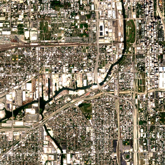
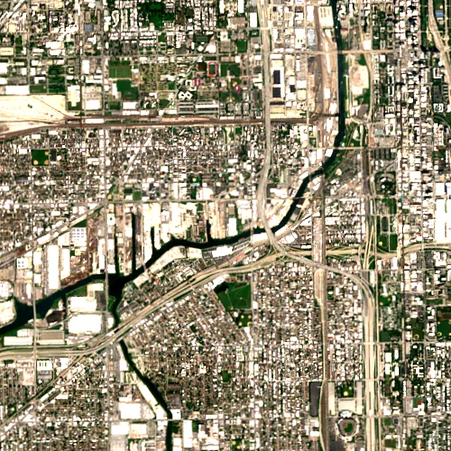

2018: satellite photo from August 2018 of a 5 × 5 km area in the city center.
- Forest lost since 2001
- 5 acres (2 ha)
- Share of its forest
- under 1%of what there was in 2000
- Cleared for good
- under 1 hadeforestation: turned into farms, mines or towns
Acres of forest lost each year
Show the figures as a table
| Year | Cleared for good | Can grow back | Total |
|---|---|---|---|
| 2001 | under 1 ha | under 1 ha | under 1 ha |
| 2002 | under 1 ha | under 1 ha | under 1 ha |
| 2003 | under 1 ha | under 1 ha | under 1 ha |
| 2004 | under 1 ha | under 1 ha | under 1 ha |
| 2005 | under 1 ha | under 1 ha | under 1 ha |
| 2006 | under 1 ha | under 1 ha | under 1 ha |
| 2007 | under 1 ha | under 1 ha | under 1 ha |
| 2008 | under 1 ha | under 1 ha | under 1 ha |
| 2009 | under 1 ha | under 1 ha | under 1 ha |
| 2010 | under 1 ha | under 1 ha | under 1 ha |
| 2011 | under 1 ha | under 1 ha | under 1 ha |
| 2012 | under 1 ha | under 1 ha | under 1 ha |
| 2013 | under 1 ha | under 1 ha | under 1 ha |
| 2014 | under 1 ha | under 1 ha | under 1 ha |
| 2015 | under 1 ha | under 1 ha | under 1 ha |
| 2016 | under 1 ha | under 1 ha | under 1 ha |
| 2017 | under 1 ha | under 1 ha | under 1 ha |
| 2018 | under 1 ha | under 1 ha | under 1 ha |
| 2019 | under 1 ha | under 1 ha | under 1 ha |
| 2020 | under 1 ha | under 1 ha | under 1 ha |
| 2021 | under 1 ha | under 1 ha | under 1 ha |
| 2022 | under 1 ha | under 1 ha | under 1 ha |
| 2023 | under 1 ha | under 1 ha | under 1 ha |
| 2024 | under 1 ha | under 1 ha | under 1 ha |
| 2025 | under 1 ha | under 1 ha | under 1 ha |
What is causing deforestation around Chicago?
- Towns and roadscleared for good42% · under 1 ha
- Unknown causescause unknown53% · 2 acres (1 ha)
Causes for 2025 are estimates, based on what caused forest loss in the same places up to 2024.
Forest gained and lost, 2000–2020
- Forest in 2000
- 5,920 acres (2,400 ha)
- Forest in 2020
- 6,260 acres (2,530 ha)
- Overall change
- +336 acres (136 ha)more forest than in 2000
Comparing satellite maps from 2000 and 2020, the forest around Chicago grew from about 5,920 acres (2,400 hectares) to 6,260 acres (2,530 hectares), a net gain of about 336 acres (136 hectares) (+5.7%). New forest grew on about 393 acres (159 hectares), while 58 acres (23 hectares) were lost.
These 2000 and 2020 maps, from the University of Maryland, count any land with trees taller than 5 m as forest, including plantations and orchards. Forest that was cut or burned and had grown back by 2020 counts in both years, so the loss here is smaller than the yearly figures.
These figures cover everything within 10 km of the city center, a wider area than the report above, because forest is usually lost at a city's edges.
Source: Hansen/UMD/Google/USGS/NASA, Global Forest Change (GFC-2025-v1.13); causes: WRI/Google DeepMind drivers of forest loss; both CC BY 4.0, summed by Airleaf for each area. Forest gained and lost 2000–2020: Potapov et al. 2022, UMD GLAD Global Land Cover and Land Use Change, CC BY 4.0. Images: contains modified Copernicus Sentinel data. How it's measured
In the same region
Measured cities near Chicago
Same 2 km radius, same index — so they compare directly.
- Naperville41.8 km
United States
- Tree cover
- 51%
- Air quality
- 74
- Joliet51.0 km
United States
- Tree cover
- 36%
- Air quality
- 70
- Elgin56.2 km
United States
- Tree cover
- 47%
- Air quality
- 69
- Aurora56.4 km
United States
- Tree cover
- 39%
- Air quality
- 74
- Kenosha82.9 km
United States
- Tree cover
- 25%
- Air quality
- 61
- South Bend117.6 km
United States
- Tree cover
- 38%
- Air quality
- 34
Also compared:Chicago vs New YorkChicago vs Los AngelesChicago vs WashingtonChicago vs Houston
Build your own
Compare Chicago with anywhere
This place
Chicago
Use this data
Put Chicago's numbers on your site
Free to embed. Updates itself as the measurement refreshes.

Frequently asked
Questions about Chicago
What is the air quality (AQI) in Chicago right now?
The latest reading for Chicago shows an AQI of 113 (Unhealthy for sensitive groups), measured Nov 11, 08:00 local time by the Cicero Liberty ground monitoring station, 5.2 mi (8.3 km) away, via OpenAQ. The main pollutant is PM2.5. Sensitive groups should limit long or intense outdoor activity.
Is it safe to exercise outside in Chicago today?
At AQI 113 (Unhealthy for sensitive groups): children, older adults and people with asthma or heart disease should cut down long or hard exercise. Windows: close them to keep the outside air out. Masks: sensitive groups: an N95 outdoors. The reading changes through the day, so check again before a long run or ride.
What has the air quality in Chicago been like this week?
Over the last 7 days, the CAMS air-quality model put Chicago's daily AQI at 34 on average, from 11 on Nov 6 to an hourly peak of 85 on Nov 10. No day averaged above 100, the level where the air turns unhealthy for sensitive groups.
Is Chicago's air quality bad?
The American Lung Association says the Greater Chicago area's air remains one of the worst in the country. Its 2026 report, based on 2022 to 2024 data, gave the Chicago-Naperville area an F for ozone and ranked it 15th worst for ozone and 13th worst for year-round particle pollution.
Why is Chicago's air sometimes smoky?
Smoke from large wildfires in Canada can drift hundreds of miles south. In June 2023 it pushed Chicago's air into the very unhealthy range, and in June 2025 the city's air ranked among the worst in the world.
When does ozone get high in Chicago?
Ozone forms when pollution from cars and industry reacts in sunlight, so it is most likely to reach unhealthy levels on hot, sunny days.
What is an Air Pollution Action Day in Chicago?
Illinois EPA calls one when the Chicago area's air is forecast to be unhealthy for sensitive groups or worse for two or more days in a row. Everyone is advised to cut back on outdoor activity, and residents and businesses are asked to cut their own pollution.
Should I wear a mask in Chicago during wildfire smoke?
Illinois health and environment officials say to consider a high-quality N95 mask if you must be outdoors in smoke. They also advise staying indoors with windows and doors closed and using high-efficiency filters.
How much forest has the area around Chicago lost since 2001?
Since 2001, the area within 10 km of Chicago has lost about 5 acres (2 hectares) of forest: under 1% of the forest it had in 2000. The biggest cause was towns and roads (42%). Almost none of it was deforestation, meaning forest cleared for good. Comparing satellite maps from 2000 and 2020, the forest around Chicago grew from about 5,920 acres (2,400 hectares) to 6,260 acres (2,530 hectares), a net gain of about 336 acres (136 hectares) (+5.7%). New forest grew on about 393 acres (159 hectares), while 58 acres (23 hectares) were lost.
What is the tree count in Chicago?
Chicago has an estimated 25,375 trees across the 4.8 sq mi (12.38 km²) of land measured — 8.2% tree cover, 27 percentage points short of the 35% tree-cover target set for this area.
How many more trees does Chicago need?
Chicago needs roughly 82,932 more trees to close a 27-point shortfall against its 35% tree-cover target — about 1,825 t of extra CO₂ absorbed per year once grown.
How are Chicago's air quality and tree cover measured?
Air quality is measured by ground monitoring stations near Pilsen, via OpenAQ; the 7-day trend is the Open-Meteo / CAMS model's estimate. Tree cover is measured from Sentinel-2 L2A (ESA Copernicus) via Earth Search satellite imagery at 10 m detail across a 1.2 mi (2 km) radius around Pilsen; the tree count is an estimate derived from that cover.
See your own area
What does your neighborhood look like?
Pick any point and radius to get the same air-quality and tree-cover breakdown.
Check my address