Air quality comparison · Ethiopia, 586 km apart
Jijiga vs Mek'ele Air quality index (AQI) today
Mek'ele has cleaner air than Jijiga right now: AQI 60 (Moderate) against 78 (Moderate).
Both sit in the same EPA band, so the health advice is the same for each today. Over the past 7 days, on modeled daily averages, Mek'ele averaged AQI 52 against 59, and it was the cleaner of the two on 5 of those days. Mek'ele has more tree cover.
Updated . Lower is better on the US EPA index: 0–50 is Good, above 300 is Hazardous. Measured by Airleaf.
Jijiga78Mek'ele60
Head to head
Jijiga vs Mek'ele at a glance
Mek'ele is ahead on 5 of 5 measures, and Jijiga on 0. The better figure in each row is marked.
| Jijiga | Mek'ele | |
|---|---|---|
| Air quality nowUS AQI. Lower is better. | 78 | 60 (better) |
| PM2.5Fine particles, µg/m³. | 25 | 13 (better) |
| Past week's averageUS AQI, 7 days. | 59 | 52 (better) |
| Tree coverWithin 2 km of the center. | 2.5% | 17.5% (better) |
| Trees still neededTo reach a healthy canopy. | 86.4K | 39.3K (better) |
Air quality today
What is the air like in Jijiga and Mek'ele right now?
Mek'ele has cleaner air than Jijiga right now: AQI 60 (Moderate) against 78 (Moderate). PM2.5 is setting the index in both.
Jijiga's PM2.5 is about 1.7× the WHO's 24-hour guideline of 15 µg/m³.
Both readings are model estimates, with no ground station close enough to either.
JijigaMek'ele
Concentrations at the same moment as the index above, for the pollutants both places report. Lower is better. The dark marks on the PM2.5 and PM10 rows show the WHO's 24-hour guidelines (15 and 45 µg/m³).
Jijiga: Model estimate · no ground station nearby. Data: Open-Meteo / CAMS, US EPA index.
Mek'ele: Model estimate · no ground station nearby. Data: Open-Meteo / CAMS, US EPA index.
The past week
Which had cleaner air over the past 7 days?
Over the past 7 days, on modeled daily averages, Mek'ele averaged AQI 52 against 59, and it was the cleaner of the two on 5 of those days. A single reading can catch a city on a bad afternoon; the week says whether it was the weather or the place.
- Cleaner days
- Jijiga1Mek'ele5
- Average AQI
- Jijiga59Mek'ele52
- Worst day, AQI
- Jijiga76Mek'ele61
The daily numbers (7 days)
| Day | Jijiga | Mek'ele |
|---|---|---|
| Nov 5 | 54 | 58 |
| Nov 6 | 50 | 50 |
| Nov 7 | 55 | 44 |
| Nov 8 | 57 | 52 |
| Nov 9 | 62 | 49 |
| Nov 10 | 62 | 47 |
| Nov 11 | 76 | 61 |
Daily averages from the CAMS atmospheric model for both places, so the week compares like with like. They can differ from today's reading at the top of the page wherever that comes from a ground station.
What it means today
Is it safe to go outside in Jijiga and Mek'ele today?
Unusually sensitive people should consider limiting long outdoor exertion. Both are in the same EPA band today (Moderate), so the advice is the same.
Exercise outdoors
Fine for most people; unusually sensitive people should take long or hard exercise easier.
Windows
Fine to open; close them if you are sensitive to pollution.
Masks
Not needed for most people.
Air purifier
Worth running if you are sensitive.
Against everywhere else
How do Jijiga and Mek'ele compare with the rest of the world?
Right now Jijiga's air is cleaner than 31% of the 5,420 places Airleaf tracks, and Mek'ele's is cleaner than 47%. Within Ethiopia, that is 14% and 38% of its 30 measured places.
Cleaner air than…
- Jijiga
- Beats 31%
- Mek'ele
- Beats 47%
More tree cover than…
- Jijiga
- Beats 5%
- Mek'ele
- Beats 40%
Includes model estimates as well as station readings, so it can differ from our most polluted and cleanest air rankings, which use station readings only.
Satellite timelapses
Watch both change, year by year
A clear satellite photo a year of the land around each city. Press play, turn on the forest cleared since the first year, or drag the before and after.
Jijiga
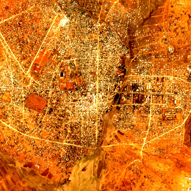
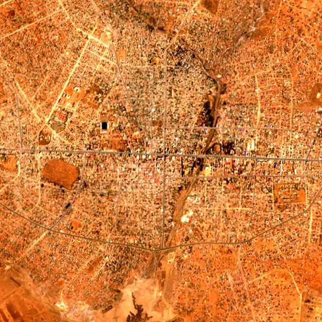

2017: satellite photo from January 2017 of a 5 × 5 km area in the city center.
Mek'ele
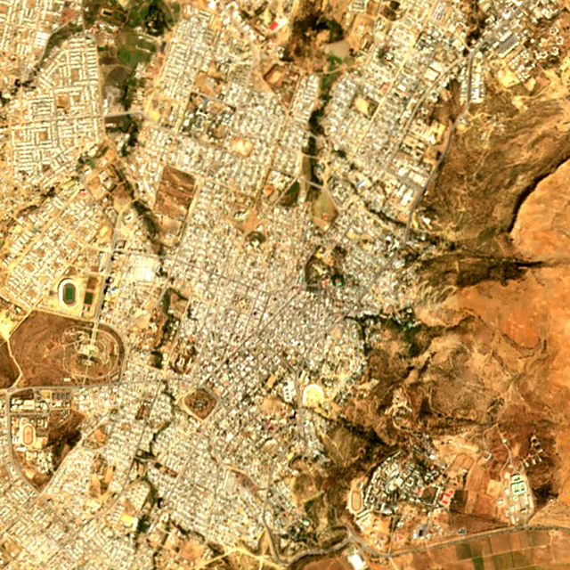
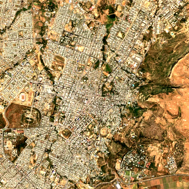

2017: satellite photo from February 2017 of a 5 × 5 km area in the city center.
Trees
Which has more trees, Jijiga or Mek'ele?
Mek'ele has more tree cover: 17.5% of the land within 2 km of its center against 2.5% around Jijiga, or about 54,978 trees against 7,854.
The dark mark is each place's canopy target: 30% of the land, raised where air quality is poor.
| Jijiga | Mek'ele | |
|---|---|---|
| Trees standingEstimated from the canopy area. | 7.9K | 55.0K (better) |
| Trees still neededTo reach the target. Fewer is better. | 86.4K | 39.3K (better) |
| CO₂ absorbed each yearBy the trees already standing. | 173K kg | 1.2M kg (better) |
Tree cover on the satellite image
The same 2 km radius around each center, with the tree cover the satellite found marked on it.
Reading these numbers
How this comparison is made
Air quality index
The US EPA index, computed from current pollutant concentrations: ground stations where a place has them nearby, and the CAMS atmospheric model everywhere else. It moves hour to hour, so it is a snapshot rather than a verdict on either place. The guideline marks are from the WHO's 2021 air quality guidelines.
Trees and forest
Tree cover is the share of ground under canopy within 2 km of each center, read from Sentinel-2 satellite imagery at 10 m detail. It measures that circle, not the whole municipality, which is what makes the two comparable. Forest loss comes from the University of Maryland's Global Forest Change maps.
More on the method on the About Airleaf page.
Frequently asked
Jijiga vs Mek'ele: your questions answered
Is Mek'ele cleaner than Jijiga?
On air quality, yes, right now: Mek'ele reads AQI 60 against 78, a gap of 18 points on the US EPA index. This is a live reading rather than an annual average, so it can reverse within a day. Over the past 7 days, on modeled daily averages, Mek'ele averaged AQI 52 against 59, and it was the cleaner of the two on 5 of those days.
Is it safe to exercise outdoors in Jijiga and Mek'ele today?
The advice is the same for both today. Unusually sensitive people should consider limiting long outdoor exertion. Jijiga reads AQI 78 and Mek'ele reads AQI 60.
Which has more trees, Jijiga or Mek'ele?
Mek'ele has more tree cover: 17.5% of the land within 2 km of its center against 2.5% around Jijiga, or about 54,978 trees against 7,854. Both figures describe the same-sized circle of ground around each center, not the whole municipality.
How many more trees do Jijiga and Mek'ele need?
Jijiga needs about 86,394 more to reach its canopy target of 30%, and Mek'ele about 39,270 to reach 30%. The target starts at 30% of the land and rises where air quality is poor.
Are Jijiga and Mek'ele measured the same way?
The method is the same: the US EPA index for air, and Sentinel-2 satellite imagery at 10 m detail over an identical radius for trees. Both readings are model estimates, with no ground station close enough to either. Nothing is adjusted for population, city limits or climate.
How often does the Jijiga vs Mek'ele comparison update?
The air readings refresh about once an hour, and each reading's local time is shown at the top of the page. Tree cover comes from the latest clear satellite image of each area (Sep 18, 2026 and Sep 9, 2026), and the forest figures are published yearly.
Keep going
Compare them with somewhere else
Build your own
Compare Jijiga with somewhere else
This place
Jijiga