City report · Dhaka Division, Bangladesh
Dhaka Air quality today
Air quality in Dhaka currently reads AQI 135 (Unhealthy for sensitive groups): Sensitive groups should limit long or intense outdoor activity.
Air quality right now
AQI 135
Unhealthy for sensitive groups
- PM2.5, fine particles (µg/m³)
- 49.5
- tree cover
- 12.8%
- trees in this area
- 37.4K
- more trees needed
- 64.8K
Measured across a 2 km radius around Tanti Bazar, Dhaka, Bangladesh (12.57 km²), from a satellite image of May 30, 2026. Lower AQI is better: 0–50 is Good, above 300 is Hazardous.
Dhaka · AQI 135 (Unhealthy for sensitive groups)
Dhaka's tree count comes to 37,357 trees across 11.68 km² of land, 22 points below the 35% tree-cover level considered healthy for this area, so roughly 64,792 more trees would close the gap.
Air quality detail
Air quality in Dhaka today: AQI 135, Unhealthy for sensitive groups
Main pollutant: PM2.5 · Observed Nov 11, 22:00 local time via OpenAQ ground stations, US EPA index. Values in µg/m³.
Ground station · Ahmedbagh, Sabujbagh | Dhaka | Smart Air Bangladesh, 3.9 km away · median of 5 stations
Health signal
Sensitive groups should limit long or intense outdoor activity.
PM2.5
49.5
PM10
—
NO₂
—
O₃
—
SO₂
—
CO
—
Data: OpenAQ · AirGradient, Smart Air Bangladesh
- Outdoor exercise
- Children, older adults and people with asthma or heart disease should cut down long or hard exercise
- Windows
- Close them to keep the outside air out
- Mask
- Sensitive groups: an N95 outdoors
- Air purifier
- Run one, especially in bedrooms
Over the last 7 days, the CAMS air-quality model put Dhaka's daily AQI at 154 on average, from 132 on Nov 4 to an hourly peak of 243 on Nov 9.
Where Dhaka stands: the most polluted cities in the world right now · the cleanest
City air guide
Why is Dhaka's air so bad in the dry season?
Right now
- Today's AQI in Dhaka is 135, unhealthy for sensitive groups, mostly from PM2.5.
- Over the past 7 days, the daily average was 154.
- November is in Dhaka's usual season for dry-season smog and brick kilns (November to March), so expect bad days to come and go until it ends.
Dhaka's air is worst in the dry months. From 2016 to 2021, fine particle levels at the US Embassy averaged about 165 to 175 µg/m³ in winter, against about 30 to 35 µg/m³ in the monsoon [1]. Brick kilns run only from November to March, and with little rain and light winds, the smoke and dust build up [1]. In 2025, IQAir ranked Dhaka the third most polluted major city in the world [3].
Why is the air worst from November to March?
PM2.5 means tiny particles in the air, small enough to reach deep into the lungs. A study of 2016 to 2021 data from the US Embassy in Dhaka found PM2.5 is highest in winter and lowest in the monsoon [1]. The highest monthly average, 180 to 210 µg/m³, always came in January [1].
In winter there is little or no rain to wash particles out of the air [1]. Winds are lighter, and the layer of air that mixes the pollution is shallow and still, so it builds up [1]. At night it is shallower still, and night levels are higher than daytime levels [1].
Brick kilns in Bangladesh run only from November to March, adding smoke in the same months [1]. A Stamford University professor who studied eight years of Dhaka data said in 2024 that about 65 to 70 percent of the yearly air pollution occurs from November to March [5].
Where does Dhaka's pollution come from?
A World Bank study found three main kinds of polluted places in Dhaka: those with persistent traffic, with major construction and traffic, and with brick kilns [2]. The highest PM2.5 levels were at sites with major construction and traffic, followed by brick kilns [2].
Estimates of each source's share differ. In 2024, an air quality director at the Department of Environment cited a 2021 to 2022 World Bank study that put brick kilns at 13 to 15 percent, construction at 11 percent and vehicles at 5 percent [5]. He said he believed vehicle emissions are higher [5]. An estimate from Stamford University's Centre for Atmospheric Pollution Studies put construction at 51 percent, industry and brick kilns at 29 percent and vehicles at 16 percent [5].
Some of the pollution blows in from outside the country. A 2023 modelling study estimated that emissions outside Bangladesh account for about half of Dhaka's yearly PM2.5 [1]. Its authors say this is one of several possible estimates and may be an upper limit [1].
How bad is it compared with other places?
In IQAir's report on 2025, Bangladesh was the second most polluted country, with an average PM2.5 level of 66.1 µg/m³ [4]. That is more than 13 times the World Health Organization's guideline [4]. Dhaka averaged 68 µg/m³, down from 78 in 2024 and 80.2 in 2023 [3]. In 2025, Dhaka had at least two months above 100 µg/m³ [4].
From 2016 to 2021, yearly averages at the US Embassy were about 80 to 98 µg/m³ [1]. In November 2024, Dhaka had 12 days rated unhealthy and 13 rated very unhealthy, and only one moderate day [6].
How does the pollution affect health?
The World Bank's Breathing Heavy study estimated that air pollution caused 78,145 to 88,229 deaths in Bangladesh in 2019 [2]. From 2009 to 2019, it was the country's second strongest risk factor for death and disability [2].
Near major construction sites in Dhaka, average PM2.5 exposure was 150 percent above the WHO's 24-hour guideline of 15 µg/m³ [2]. Older people, young children and people with diabetes, heart or lung disease were found to be most at risk [2].
What is being done about it?
From January 2 to July 10, 2025, the Department of Environment ran 1,191 mobile courts across Bangladesh [7]. It demolished the chimneys of 483 illegal brick kilns and ordered 216 more to close [7]. The drives also targeted black smoke from unfit vehicles and polluting industries [7].
In November 2024, Dhaka North City Corporation said it waters major roads in the mornings and evenings to keep dust down, and Dhaka South planned to start [5]. Both said they fine people who leave construction materials uncovered [5].
How to protect yourself in Dhaka
On days with high particle pollution, pay attention to local air quality reports and alerts [8]. Avoid strenuous or long work or exercise outdoors [8].
Indoors, keep windows and doors closed unless it is very hot, and keep any fresh-air intake closed [8]. Air cleaners can help lower indoor particles, but do not use one that makes ozone [8]. Avoid frying, candles and anything that burns indoors [8].
If you need to be outside, a mask only protects you if it filters very small particles and fits well. Surgical masks and cloth face coverings give far less protection, or none [8].
Sources
- [1] Atmospheric Environment (via PubMed Central), Characterizing variations in ambient PM2.5 concentrations at the U.S. Embassy in Dhaka, Bangladesh using observations and the CMAQ modeling system (January 2023)
- [2] World Bank, In Bangladesh, an urgent call for clean air (December 2022)
- [3] IQAir, 5 Most polluted major cities in the world in 2025 (June 2026)
- [4] bdnews24.com, Bangladesh remains world's second most polluted country in 2025, data shows (March 2026)
- [5] bdnews24.com, Air quality crisis: Dhaka struggles with dangerous pollution levels (November 2024)
- [6] Prothom Alo, Air pollution choking Dhaka, other major cities (December 2024)
- [7] The Business Standard, Over 1,100 mobile courts conducted, 699 brick kilns shut down in anti-pollution drives (July 2025)
- [8] US EPA, Patient Exposure and High Particle Pollution Events (April 2026)
Last reviewed . The figures in the box at the top update with every new reading; the guide itself is checked against its sources at least once a year, before the city's bad-air season.
Tree cover detail
Tree cover in Dhaka: Critically low
12.8% tree cover against a 35% healthy-neighborhood target, across 11.68 km² of land.
Trees in this area
37,357
Target trees
102,149
More trees needed
64,792
CO₂ if planted / yr
1,425 t
Deforestation · 2001–2025
How much forest has Dhaka lost?
Since 2001, the area within 10 km of Dhaka has lost about 12 hectares of forest (about 17 football pitches): 6.8% of the forest it had in 2000. Most of it (50%) was deforestation, forest cleared for good, mainly for towns and roads.
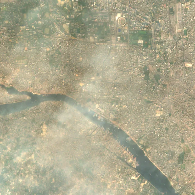
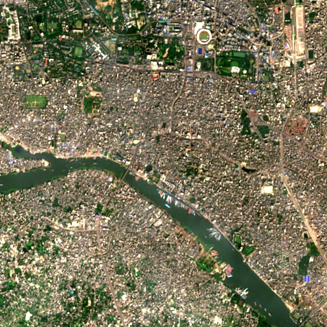

2017: satellite photo from January 2017 of a 5 × 5 km area in the city center.
- Forest lost since 2001
- 12 haabout 17 football pitches
- Share of its forest
- 6.8%of what there was in 2000
- Cleared for good
- 6 hadeforestation: turned into farms, mines or towns
The worst year was 2011, when about 3 hectares of forest were lost.
Hectares of forest lost each year
Show the figures as a table
| Year | Cleared for good | Can grow back | Total |
|---|---|---|---|
| 2001 | under 1 ha | under 1 ha | under 1 ha |
| 2002 | under 1 ha | under 1 ha | under 1 ha |
| 2003 | under 1 ha | under 1 ha | under 1 ha |
| 2004 | under 1 ha | under 1 ha | 1 ha |
| 2005 | under 1 ha | under 1 ha | under 1 ha |
| 2006 | under 1 ha | under 1 ha | under 1 ha |
| 2007 | under 1 ha | under 1 ha | under 1 ha |
| 2008 | 1 ha | under 1 ha | 2 ha |
| 2009 | under 1 ha | under 1 ha | under 1 ha |
| 2010 | under 1 ha | 1 ha | 2 ha |
| 2011 | 1 ha | 1 ha | 3 ha |
| 2012 | under 1 ha | 1 ha | 1 ha |
| 2013 | under 1 ha | under 1 ha | under 1 ha |
| 2014 | under 1 ha | under 1 ha | under 1 ha |
| 2015 | under 1 ha | under 1 ha | under 1 ha |
| 2016 | under 1 ha | under 1 ha | under 1 ha |
| 2017 | under 1 ha | under 1 ha | under 1 ha |
| 2018 | under 1 ha | under 1 ha | under 1 ha |
| 2019 | under 1 ha | under 1 ha | under 1 ha |
| 2020 | under 1 ha | under 1 ha | under 1 ha |
| 2021 | under 1 ha | under 1 ha | under 1 ha |
| 2022 | under 1 ha | under 1 ha | under 1 ha |
| 2023 | under 1 ha | under 1 ha | under 1 ha |
| 2024 | under 1 ha | under 1 ha | under 1 ha |
| 2025 | under 1 ha | under 1 ha | under 1 ha |
What is causing deforestation around Dhaka?
- Towns and roadscleared for good43% · 5 ha
- Farms, pasture and plantationscleared for good6.7% · under 1 ha
- Unknown causescause unknown50% · 6 ha
Causes for 2025 are estimates, based on what caused forest loss in the same places up to 2024.
Forest gained and lost, 2000–2020
- Forest in 2000
- 1,490 ha
- Forest in 2020
- 1,700 ha
- Overall change
- +207 hamore forest than in 2000
Comparing satellite maps from 2000 and 2020, the forest around Dhaka grew from about 1,490 hectares to 1,700 hectares, a net gain of about 207 hectares (+14%). New forest grew on about 284 hectares, while 77 hectares were lost.
These 2000 and 2020 maps, from the University of Maryland, count any land with trees taller than 5 m as forest, including plantations and orchards. Forest that was cut or burned and had grown back by 2020 counts in both years, so the loss here is smaller than the yearly figures.
These figures cover everything within 10 km of the city center, a wider area than the report above, because forest is usually lost at a city's edges.
Source: Hansen/UMD/Google/USGS/NASA, Global Forest Change (GFC-2025-v1.13); causes: WRI/Google DeepMind drivers of forest loss; both CC BY 4.0, summed by Airleaf for each area. Forest gained and lost 2000–2020: Potapov et al. 2022, UMD GLAD Global Land Cover and Land Use Change, CC BY 4.0. Images: contains modified Copernicus Sentinel data. How it's measured
In the same region
Measured cities near Dhaka
Same 2 km radius, same index — so they compare directly.
- Narayanganj14.5 km
Bangladesh
- Tree cover
- 26%
- Air quality
- 132
- Tungi20.1 km
Bangladesh
- Tree cover
- 20%
- Air quality
- 149
- Savar22.2 km
Bangladesh
- Tree cover
- 45%
- Air quality
- 143
- Sonārgaon22.3 km
Bangladesh
- Tree cover
- 66%
- Air quality
- 156
- Narsingdi39.4 km
Bangladesh
- Tree cover
- 54%
- Air quality
- 150
Also compared:Dhaka vs ChattogramDhaka vs KhulnaDhaka vs Rangpur
Build your own
Compare Dhaka with anywhere
This place
Dhaka
Use this data
Put Dhaka's numbers on your site
Free to embed. Updates itself as the measurement refreshes.
Frequently asked
Questions about Dhaka
What is the air quality (AQI) in Dhaka right now?
The latest reading for Dhaka shows an AQI of 135 (Unhealthy for sensitive groups), measured Nov 11, 22:00 local time by 5 ground monitoring stations via OpenAQ (the median of their readings; the nearest is Ahmedbagh, Sabujbagh | Dhaka | Smart Air Bangladesh, 3.9 km away). The main pollutant is PM2.5. Sensitive groups should limit long or intense outdoor activity.
Is it safe to exercise outside in Dhaka today?
At AQI 135 (Unhealthy for sensitive groups): children, older adults and people with asthma or heart disease should cut down long or hard exercise. Windows: close them to keep the outside air out. Masks: sensitive groups: an N95 outdoors. The reading changes through the day, so check again before a long run or ride.
What has the air quality in Dhaka been like this week?
Over the last 7 days, the CAMS air-quality model put Dhaka's daily AQI at 154 on average, from 132 on Nov 4 to an hourly peak of 243 on Nov 9. On 7 of those days the average was above 100, unhealthy for sensitive groups.
When is Dhaka's air quality worst?
In the dry season, from November to March, and most of all in winter. From 2016 to 2021, the highest monthly average always came in January. The air is cleanest in the monsoon, from June to September.
Why is Dhaka's air so polluted?
Traffic, construction dust and brick kilns are the main local sources, and some of the fine particles blow in from outside Bangladesh. In the dry months, little rain, light winds and a shallow layer of mixing air let the pollution build up.
Are brick kilns the main cause of Dhaka's air pollution?
They are one of several. Brick kilns run from November to March, but estimates of their share vary, from 13 to 15 percent in one World Bank study. Construction, traffic and pollution from outside the country also matter.
How polluted was Dhaka in 2025?
IQAir ranked Dhaka the third most polluted major city in the world in 2025, with an average PM2.5 level of 68 µg/m³. Bangladesh was the second most polluted country, at more than 13 times the WHO guideline.
How much forest has the area around Dhaka lost since 2001?
Since 2001, the area within 10 km of Dhaka has lost about 12 hectares of forest (about 17 football pitches): 6.8% of the forest it had in 2000. Most of it (50%) was deforestation, forest cleared for good, mainly for towns and roads. Comparing satellite maps from 2000 and 2020, the forest around Dhaka grew from about 1,490 hectares to 1,700 hectares, a net gain of about 207 hectares (+14%). New forest grew on about 284 hectares, while 77 hectares were lost.
What is the tree count in Dhaka?
Dhaka has an estimated 37,357 trees across the 11.68 km² of land measured — 12.8% tree cover, 22 percentage points short of the 35% tree-cover target set for this area.
How many more trees does Dhaka need?
Dhaka needs roughly 64,792 more trees to close a 22-point shortfall against its 35% tree-cover target — about 1,425 t of extra CO₂ absorbed per year once grown.
How are Dhaka's air quality and tree cover measured?
Air quality is measured by ground monitoring stations near Tanti Bazar, via OpenAQ; the 7-day trend is the Open-Meteo / CAMS model's estimate. Tree cover is measured from Sentinel-2 L2A (ESA Copernicus) via Earth Search satellite imagery at 10 m detail across a 2 km radius around Tanti Bazar; the tree count is an estimate derived from that cover.
See your own area
What does your neighborhood look like?
Pick any point and radius to get the same air-quality and tree-cover breakdown.
Check my address